

Or
How to land at an airfield in IMC weather conditions without a published approach procedure
(For Microsoft Flight Simulator, not real life)
For use with Epic Ops Flight Series
A generic instrument approach procedure may consist of:
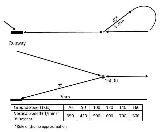
1. Overfly the destination airfield
2. Outbound leg 180 degrees to runway heading (or other heading as required for terrain clearance)
3. Procedure turn to reverse course 180 degrees (eg. 45 degrees for 1 min)
4. Final approach fix (FAF) with 3 degree glide path to runway threshold (eg. 5nm from runway threshold and 1600ft above runway elevation)
5. Final approach 3 degree descent: Vertical speed (VS) = Groundspeed (GS) divide by 2 and add 0 (eg. 100kts GS = 500 ft/min VS)
6. Descend to a minimum descent height (MDH) eg. 400ft (above runway elevation)
Generic Instrument Approach Procedure
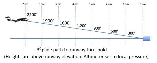
Other 3 Degree Glide Path Distances and Heights
Flight Planning (using Little Navmap)
Setup:
- Use an aircraft profile with a 3 degree descent angle (3.1nm per 1000ft)
- If nearby terrain (mountains), use the Little Navmap vertical profile display to aid with terrain clearance for the flight plan (with GLOBE elevation data installed)
Options for waypoints (airfield, FAF):
- Use existing navaid (VOR, NDB) bearing and distance (DME)
- Use GPS waypoint (airfield, fix or custom waypoint)
Add waypoints to flight plan:
- Destination airfield (for overfly)
- Final approach fix (FAF) (5nm from runway threshold or other distance as required)
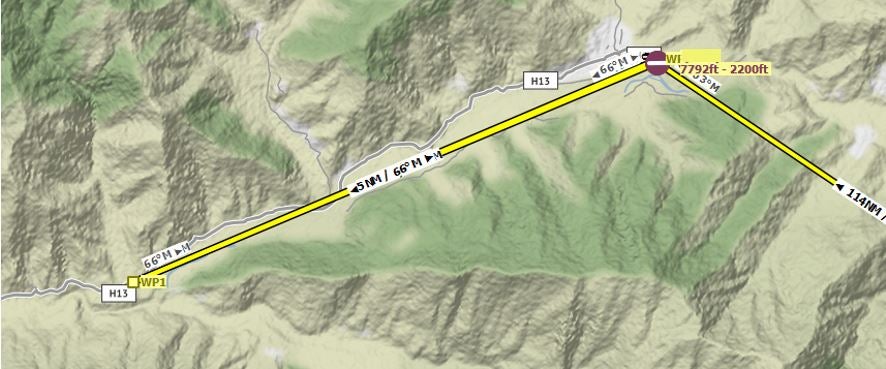
Tip: Right click on map to add custom waypoint or right click on Airfield - Select Destination Runway - to add FAF including offset approach.
Optional: Runway threshold waypoint (so waypoint distances are from runway threshold and can set the waypoint altitude as the runway elevation for a more accurate vertical profile (in aircraft GPS/FMC).
Optional: If using an offset approach (final approach heading is different to runway heading), can add a late final turn waypoint to align with runway heading.
Tip: If the destination airfield overfly has an acute turn angle, overfly the airfield using a procedure turn to reverse course and align with the outbound leg from the airfield.
Export flight plan as pln format.
Offset Approach
Flight Operation
Load the flight plan in MSFS World Map and/or in aircraft GPS/FMC.
Tip: Custom waypoints should import or create custom waypoints in aircraft GPS/FMC. Can utilize GPS/FMC "visual approach" procedure to create a FAF (straight-in approach) (for aircraft with those functions).
Add waypoint altitudes in aircraft GPS/FMC (for aircraft with that function).
Fly the lateral and vertical profile as per the flight plan:
1. Descend from top of descent (TOD) (eg. use VS (3 degree) or Vnav)
2. Overfly destination airfield and fly outbound leg
3. Hold altitude at procedure turn (with adequate terrain clearance for turn. Can use terrain radar to aid with terrain awareness (for aircraft with that function)
4. Procedure turn to reverse course (lower airspeed will reduce turn radius)
5. Intercept FAF (5nm from runway threshold and 1600ft above runway elevation, or other distance and height as required)
6. Final approach descent at required vertical speed (VS (3 degree) or Vnav)
7. Descend to MDH
8. Land when visual contact made with runway
Optional: Before the procedure turn waypoint, can use suspend waypoint sequencing (eg. OBS mode etc) to keep the waypoint active for after the procedure turn is complete (remember to then re-engage sequencing) (for aircraft with that function)
Optional: Can use the GPS/FMC "OBS" or "intercept course" function to create an extended runway centre line and use that as the outbound or inbound leg. Can also use the "Direct To" function with a course set (for aircraft with that function)
Optional: If using Vnav and are above the Vnav path (eg. to increase terrain clearance), can use Vnav Direct to a later waypoint to create a new (steeper) Vnav path (for aircraft with that function)
Go to Epic Ops Flight Series